


by Hugo Barsacq-Camard, Undergraduate Student Intern, McGill Visual Arts Collection
On the second floor of McGill’s Faculty Club, hangs a massive historical map that was printed in 1654. The lower two-thirds of the 225 x 200 cm engraving is a topographical map of the fortified town of Arras, France. Inside the garrison walls of the town are hundreds of French army horses, tents, and soldiers, each painstakingly depicted by the artist and engraver. The surrounding hills of the northern French city are also crowded with fleeing Spanish army battalions on foot and on horseback. The top third of the print offers a landscape view of the same scene. Here the church spires and town hall buildings stand tall in the face of the ensuing battle. Both birds-eye and hillside views are framed by an elaborate leafy border and winged cherubs hold up royal portraits and heraldry of King Louis XIV at the top. On the bottom, portraits of the commanding officers and generals are encircled with foliage-filled frames, complete with scrolls and armour.
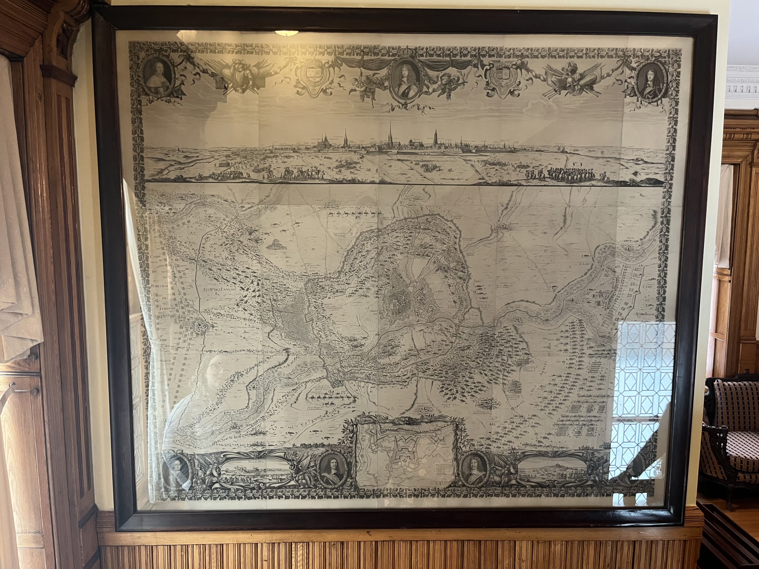
Jean Frosne (1623-1676) and Nicolas Cochlin (1610-1678) Engravers, French
The Battle of Arras, 1654, Engraving, 225 x 200 cm
McGill Visual Arts Collection, 1984-002
In the McGill Visual Arts Collection’s paper files on this map, there was a curious inscription. Under significance to the University – where past Visual Arts Committee members usually wrote who donated the artwork or the provenance of the piece – there was this uncommon phrase: “Apparently given to Sir Arthur Currie by the French after the 2nd battle of Arras during WWI?” This information was likely passed down over the years and inscribed in our paper files with the hopes that more research would be done in the future.

Certainly, the word, “apparently” and that lingering question mark on a catalogue sheet are clear invitations for more research! As a a second-year Anthropology major with a minor in Environment who has taken Art History classes, I was keen to unearth the real story behind this impressive map that is at the cross-section of history and art.
In 1654, the Spanish sieged the city of Arras in the north of France but were defeated by French reinforcements. The battle is famous as young Louis XIV’s first military victory as king. A map was drawn on site by the cartographer and engineer, Sébastien de Beaulieu who presented it to the young monarch, then only 16, who would come to rule over France for 72 years. The original map was etched by, Jean Frosne and Nicolas Cochin, and was encompassed by a text recounting the battle. Measuring over two meters square, the map is made up of sixteen separate sheets pasted together.
Here at McGill, the persisting legend is that this copy of the map was a gift to General Arthur Currie given by the grateful French government after the battle of Vimy Ridge in 1917, not far from Arras. Since Currie became Principal of McGill University in 1920 and lived in this building, the extraordinary engraving, commemorating the earlier Battle of Arras would have been an appropriate decoration recalling his own victories in World War I during the Battle of Vimy Ridge – only 11km from Arras.
The gift-giver, however, was not the grateful French government. With archival research in the McGill University Archives, it was discovered that the map was given to the University by the Principal’s wife, Lucy Chaworth-Musters, also known as Lady Currie. According to the minutes of the Faculty Club meeting on March 17, 1953, she explained that the map was purchased at Eatons. While we might find it odd to think of a department store as a place to purchase Fine Art, in the first half of the 20th century, it was often where collectors would go to select paintings and prints to decorate their homes.
Now, this map, which is an important historical artifact with indisputable significance to the University, is on display for us to share with visitors to the Faculty Club.
If you would like to see the map in more detail, you can see a high-resolution digitized image of another edition of the same map from the Royal Collection Trust here.


Leave a Reply
You must be logged in to post a comment.